Birds eye view
Here is a comparison between Chris Holton's excellent drone view of Bradford on Avon looking Eastward, and the same birds eye view in 1011. All archaeological reports have been included. So have expert opinions that I've assessed to have a good or reasonable level of certainty. I've created connections (sometimes very obvious ones when you're actually there in 3D) between this information, to create what I think is a full and fluid picture.
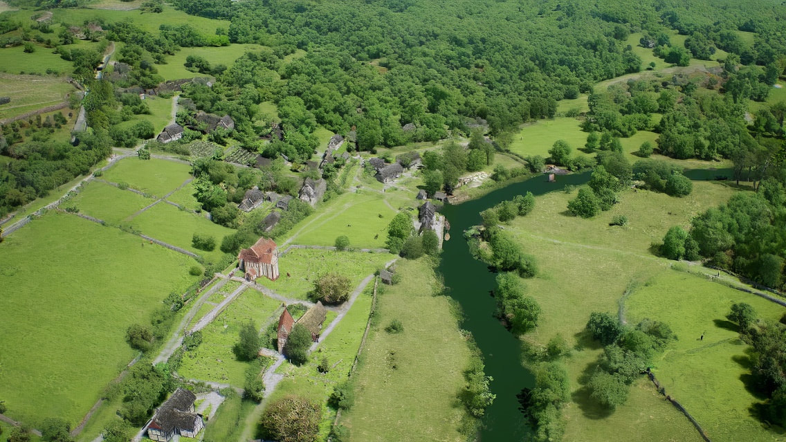
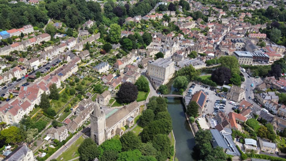
You can see the Saxon church is kind of central in both pictures. Also, in contrast to Chris's present day photo, where most of the trees are mature, in 1011 most of the trees are young, as they were regularly harvested, and especially so on the slopes around Whitehill and Coppice Hill, where they're harvested systematically by coppicing.
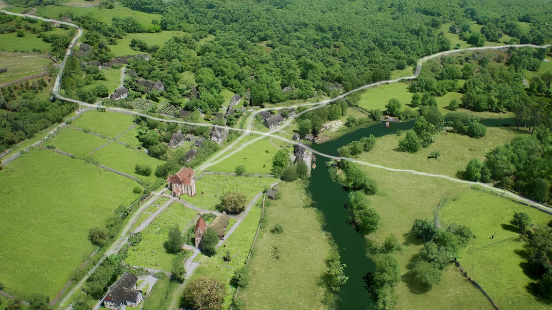
Roads North to south
Below I've highlighted where I think the main roads were in 1011, (present day view is below for comparison). If we start at the top left-hand corner, we're coming down Conigre from the Winsley Road, and we have to bend to the right as we do today to avoid an unworkably steep slope. We continue on down towards Newtown where unlike today, the Road isn't diverted but flows from Conigre, straight into what is now the very top part of Rosemary steps. Instead of following the present diverted route of Rosemary steps, we go straight down the slope at a gentler more mule friendly angle to Druces Hill, on a road which has now been quarried away. You'll see Druices Hill lies on a crossroads. We go over that and on through what is now Abbey Mills, over the Anglo Saxon Ford and up through what is now St Margaret's car park and on to the far right of shot to St Margaret's Street.
Below I've highlighted where I think the main roads were in 1011, (present day view is below for comparison). If we start at the top left-hand corner, we're coming down Conigre from the Winsley Road, and we have to bend to the right as we do today to avoid an unworkably steep slope. We continue on down towards Newtown where unlike today, the Road isn't diverted but flows from Conigre, straight into what is now the very top part of Rosemary steps. Instead of following the present diverted route of Rosemary steps, we go straight down the slope at a gentler more mule friendly angle to Druces Hill, on a road which has now been quarried away. You'll see Druices Hill lies on a crossroads. We go over that and on through what is now Abbey Mills, over the Anglo Saxon Ford and up through what is now St Margaret's car park and on to the far right of shot to St Margaret's Street.

Roads East to west
Below I've highlighted where I think the main roads were in 1011, (present day view is below for comparison). Now we go East to west on a road that follows the River while avoiding boggy ground and flooding. We start in the top right hand corner coming down Silver street, at the bottom of the hill we go through the shambles until at the current site of the town hall/ Catholic Church, we come to a fork in the road. Left takes us down the present route of Church Street to an inn and packhorse waystation. The right hand of the fork is a continuation of the main road and goes right through the present day Town Hall and Banks and joins up with Druces Hill. You can see that it appears to have been diverted around the inn and packhorse way station as it grew larger. The Road then goes over the crossroads at Druces Hill and from there straight on to the north side of the Saxon church. This was before there was a good deal of land slippage, so at that time there was enough room for the Road, which carried on Past the vicarage and on out of shot, straight through what is now the chantry and on to become Belcombe road. Which itself I think was later diverted so it could join up with Newtown rather than Barton orchard. Yes, a thousand years is a long time :)
Below I've highlighted where I think the main roads were in 1011, (present day view is below for comparison). Now we go East to west on a road that follows the River while avoiding boggy ground and flooding. We start in the top right hand corner coming down Silver street, at the bottom of the hill we go through the shambles until at the current site of the town hall/ Catholic Church, we come to a fork in the road. Left takes us down the present route of Church Street to an inn and packhorse waystation. The right hand of the fork is a continuation of the main road and goes right through the present day Town Hall and Banks and joins up with Druces Hill. You can see that it appears to have been diverted around the inn and packhorse way station as it grew larger. The Road then goes over the crossroads at Druces Hill and from there straight on to the north side of the Saxon church. This was before there was a good deal of land slippage, so at that time there was enough room for the Road, which carried on Past the vicarage and on out of shot, straight through what is now the chantry and on to become Belcombe road. Which itself I think was later diverted so it could join up with Newtown rather than Barton orchard. Yes, a thousand years is a long time :)